CHAKRATA HILL STATION
Chakrata, Dehradun, Uttarakhand, India
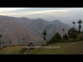
Chakrata is a small hill town near Dehradun in Uttarakhand, located at a height of 6948 feet known for its coniferous forest, treks, caves and ancient temples. With mountain climbing as one of the popular activities in Chakrata, it is also becoming a popular destination for camping. With some of the beautiful waterfalls, especially Tiger Falls, Chakrata is a backpacker's paradise and an ideal location for people seeking offbeat tranquil destinations. The highest peak in the hilltown is Kharamba Peak, located at an altitude of 10,000 feet surrounded by dense forests and nature's bounties. The forests of Chakrata is home to diverse wildlife like wild fowls, panther and spotted deer. Once a small hamlet of Jaunsari tribe called Jaunsar Bawar, Chakrata looks down upon the Yamuna valley. The place was developed by the executives of the East India Company and it also encloses a military cantonment making the access restricted for civilian travellers.
Suggested time duration
5 HoursCrowded Period
WeekendBest Season To Visit
March to July


Do's & Dont's
- Do not enter restricted zone, which is meant for your safety.
- Do not consume liquor.
Architecture
Curabitur tempus quam id neque placerat ultricies. Duis ligula elit, faucibus ac diam nec, tristique scelerisque metus. Donec condimentum nunc nec suscipit blandit. Vivamus nulla nunc, sodales non risus sed, vehicula commodo velit. Praesent quis ipsum sed massa commodo gravida et sit amet quam. Curabitur tempus quam id neque placerat ultricies. Duis ligula elit, faucibus ac diam nec, tristique scelerisque metus. Donec condimentum nunc nec suscipit blandit. Vivamus nulla nunc, sodales non risus sed, vehicula commodo velit. Praesent quis ipsum sed massa commodo gravida et sit amet quam. Curabitur tempus quam id neque placerat ultricies. Duis ligula elit, faucibus ac diam nec, tristique scelerisque metus. Donec condimentum nunc nec suscipit blandit. Vivamus nulla nunc, sodales non risus sed, vehicula commodo velit. Praesent quis ipsum sed massa commodo gravida et sit amet quam.Timings
| Day | Start Time | End Time | Adult Entry Fee | Child Entry Fee |
|---|---|---|---|---|
| All Days | 08:00 AM | 07:00 PM | Free | Free |
Transport Connections
| Name | Distance | Contact Number |
|---|---|---|
| |
108 KM | 18001210802 |
|
|
187 KM | 139 |
| |
206 KM | 01772736835 |
What to Carry
- Carry Water Bottle and Snacks
Suitable For
Facilities
Parking
Parking is Available for 15 CarsNearest Town
| Town Name | Distance |
|---|---|
| Lal Kurti | 1 KM |
Nearest Temples
 MINDROLLING MONASTERY
Mindrolling monastery is one of the six monasteries of the Nyingma school of Buddhism
SHRI SHAKUMBHARI DEVI TEMPLE
It is believed that Ma Shakumbari killed Mahishasur Maha Daitya here
Nearest Attractions
 TrekkingCHOPTA TUNGNATH TREKKING
Surrounded by dense forests and oak trees
 OutdoorFUN N FOOD KINGDOM
This Amusement Park has a water park with water slides
 MuseumK DEVBHUMI WAX MUSEUM
Museum houses 26 statues of some prominent personalities
 WildlifeBENOG WLS
Famous for its mountain quails and red-billed blue magpie
 CavesBUDHER CAVES
This cave is most popular spot for Spelunking
 Boating ASAN BARRAGE BOATING
It is meeting point of Eastern Yamuna Canal and Asan River
 Rope WayGUN HILL MUSSOORIE ROPEWAY
Gun Hill Mussoorie is one of the best ropeway in India
 WaterfallsKEMPTY WATERFALLS
Nestled at altitude of around 4500 ft above the sea level
User Reviews
Map